Executive Summary
CHAPTER I. INTRODUCTION
Background
 The goal of this Natural Resources Report is to provide a scientifically accurate account of the distribution and characteristics of Nevada County’s ecosystems and plant and animal species. This report and its associated maps and electronic databases can be used for the next General Plan update. They should also enable the Board of Supervisors (Board) and the Community Development Agency staff to make more informed decisions on the immediate and cumulative effects of various projects on the county’s natural resources. At the Board’s direction, this report is a data summary only and it does not contain any conclusions, recommendations, or rankings of the county’s watersheds or natural resources.
The data and findings of this report are not intended to be a substitute for site-specific surveys and biological resource analysis on lands that are proposed for future development or land use conversions. However, this report will provide much useful information on Nevada County’s biological resources for local, state and federal agencies, private landowners, land trusts, developers, scientific organizations, and members of the general public.
Scientific Advisory Committee and Science Team
The Scientific Advisory Committee (SAC) for the Natural Heritage 2020 project consisted of seven highly qualified scientists from universities, state and federal agencies, and non-governmental organizations. The SAC was advisory to the Board and to the Community Advisory Committee and its working groups. A Science Team was hired by the Sierra Business Council to obtain information on the county’s biological resources, to organize this information into a Geographic Information System (GIS) electronic database, and to verify the information in the field.
CHAPTER 2. METHODS
Mapping by Watershed
Watersheds were selected as the units for mapping the physical and biological resource information (Appendix IX). Nevada County has three major drainage basins or watersheds, the Yuba, Bear, and Truckee. The Yuba and Bear rivers originate near the Sierra Crest and drain into the Feather River which in turn drains into the Sacramento River and eventually the Pacific Ocean. The Truckee River originates in Lake Tahoe and flows to Pyramid Lake, Nevada. Each of these large river drainages can be subdivided into smaller watersheds. The California Watershed Map (CALWATER 2.0) lists 98 planning watersheds greater than 150 acres in Nevada County; the division of the unusually large Wolf Ditch watershed into three sub-basins yielded the final 100 watersheds used in this report.
Compilation of the Databases
Biological and physical resource information for each watershed was obtained from a variety of published sources and existing electronic databases that are maintained by universities and local, state, and federal agencies. Only the most current, scientifically accurate information available was used. More than 200 electronic databases were evaluated, but only about 40 of these were incorporated into the GIS database (Appendix VII).
Vegetation maps were prepared for each watershed using existing maps and aerial photographs. Vegetation types that could be mapped and field-verified at a watershed scale (i.e., continuous patches > 10 acres in extent) were defined as “large-patch ecosystems” and classified using the California Wildlife Habitat Relationship (CWHR) system, modified slightly to reflect conditions in Nevada County. CWHR was selected over other habitat classification systems because it is widely used by foresters and wildlife biologists throughout California and is the system most easily understood by decision makers and the general public.
The approximate locations of small-patch ecosystems (i.e., small, biologically important plant, soil, or aquatic communities that are too small to be mapped accurately at a watershed scale) also were noted on the watershed maps. Other themes that were entered into the GIS database include canals, dams and reservoirs, public/private roads, roadless areas, roads in streamside zones, development in streamside zones, contiguous unimproved lands, NID arable lands, NID irrigated lands, and public or private land ownership.
Species lists of vascular plants (Appendix I) and vertebrate animals (Appendix IV) were compiled from university and agency databases, published literature, and consultations with agency personnel and knowledgeable local naturalists. “Redlist” species were defined as taxa that are listed as threatened, endangered, or candidates on state or federal endangered species lists. “Yellowlist” species include all other sensitive or special concern taxa that are included in state or federal agency or California Native Plant Society lists. Summaries of Redlist and Yellowlist plants (Appendix II) and vertebrates (Appendix V) with known or potential occurrences in the county were prepared.
A Nevada County Wildlife Habitat Relationship (NCWHR) matrix was prepared to summarize the occurrence of native vertebrates in each of the county’s large-patch ecosystems (Appendix VI). A matrix of the NCWHR habitat associations of all Redlist and Yellowlist plants also was prepared (Appendix III).
Verification and Validation
All selected data themes were evaluated in both the office and field to verify their accuracy. The Science Team performed reconnaissance-level surveys in each of the 100 watersheds to field-verify the GIS-based maps and databases to ensure that they were accurate. Access to individual watersheds was gained through public roads, public lands, and some private lands by written invitation from the owners. No trespassing on private lands occurred during the field surveys.
Peer Review
A draft report was prepared and internally reviewed by the Science Team. Summaries of plant and animal occurrences, including listed and other Redlist and Yellowlist species, were critiqued by several agency and private-sector biologists with detailed knowledge of the northern Sierra Nevada. The draft report was reviewed by members of the SAC who provided detailed comments on the text, the associated appendices, and the GIS-based maps. Their suggestions were incorporated into a second draft report that was sent for further peer review to other biologists selected by citizens groups from within the county.
CHAPTER 3. RESULTS
Species Occurrence and Habitat Relationships
Plant diversity
Nevada County supports a rich flora of 1,841 documented plant species. This represent about 26% of the total number of plant species in California. Approximately 350 of the 1,841 species are non-natives. Several species reach their distributional limits in the County (e.g., whitebark pine), and a few species, such as knobcone pine, have disjunct populations here. Disjunct populations may be genetically unique and vulnerable to extinction.
Redlist and Yellowlist plant species
Only four plant species that occur in Nevada County are listed as either Threatened or Endangered under the federal or state Endangered Species Acts (Redlist species). These include Tahoe yellow cress (possibly extirpated in the county), Scadden Flat checkerbloom, Stebbins’ morning glory, and Pine Hill Flannelbush.
A total of 76 Yellowlist plants occur in the county, including eight endemic or highly localized species: Cedar Crest popcornflower, Torrey’s buckwheat, starved daisy, long-petaled lewisia, and four mosses. Redlist and Yellowlist plants are most likely to be associated with Montane Meadows, Barren Areas (rock outcrops), and Serpentine and Gabbrodiorite soils. The majority of these ecosystems are on private lands.
Non-native plants
About 19% of Nevada County’s flora are non-native plant species. Some of these aggressive, invasive exotics present serious problems because they degrade natural areas, exclude native species, disrupt ecosystem processes, alter fire frequencies, reduce recreational values, and restrict economic returns on crops. The most widespread invasives in Nevada County are yellow star-thistle, ripgut brome, medusa-head, and Italian thistle. Scotch broom, Himalayan blackberry, and cheatgrass also are frequent pests.
Animal diversity
Vertebrate animals in Nevada County include 333 regularly occurring native species, 45 introduced species, and 52 infrequently observed species (recorded five or fewer times). The county’s fauna consists of 22 native and 33 introduced species of fishes, nine native and one introduced amphibian, 21 native reptiles, 214 native and five introduced birds, and 67 native and six non-native mammals (Appendix IV).
Redlist and Yellowlist species
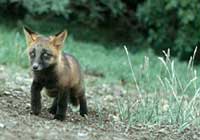
Fifteen Redlist species have known or potential occurrence in the county: valley elderberry longhorn beetle, Central Valley chinook salmon, Central Valley steelhead, Lahontan cutthroat trout, Calfornia red-legged frog, bald eagle, Swainson’s hawk, American peregrine falcon, black rail, sandhill crane, great gray owl, bank swallow, willow flycatcher, Sierra Nevada red fox, and California wolverine (Appendix V). The highest numbers of Redlist vertebrates occur in Fresh Emergent Wetlands, Montane Meadows, and Barren Areas (Appendix VI).
A total of 47 Yellowlist vertebrates and 11 invertebrates are known to occur or potentially occur in Nevada County (Appendix V). The highest numbers of these species are associated with Foothill Hardwood, Montane Hardwood, Eastside Riparian, Mixed-Conifer, Ponderosa Pine, and Montane Riparian ecosystems.
Detailed discussions of plant and animal occurrences in Nevada County are presented in the results section of this report. Topics covered are plant and animal diversity, unique features of Nevada County’s native plants, non-native invasive plants (noxious weeds), and information on individual Redlist and Yellowlist plant and animal species and their known and potential habitat associations. This section is followed by detailed discussions of each of Nevada County’s ecosystems. Each ecosystem account contains information on its structural and ecological characteristics, plant and animal diversity, and distribution and status.
There are 27 large-patch and 10 small-patch ecosystem types in Nevada County. Their occurrence in the county is defined by one or more of these elevation zones:
- Zone 1: Foothill Watersheds
- Zone 2: Transitional Watersheds
- Zone 3: Westside Conifer Watersheds
- Zone 4: Eastside Watersheds
Large-Patch Ecosystems—Aquatic
Riverine (Elevation Zones 1-4)
Riverine ecosystems occupy a relatively small proportion of the total landscape in Nevada County, but they are extremely important ecologically. These ecosystems support a fish fauna of 22 native and 33 non-native species, many birds, mammals, amphibians, and reptiles, and a high diversity of invertebrates that are important links in aquatic food chains. Riverine ecosystems at lower elevations in Nevada County have been heavily impacted by hydraulic mining, dam construction, the introduction of exotic fishes and amphibians, and poor water quality. As a result, many species of invertebrates, fish, and amphibians inhabiting these ecosystems are in decline.
Lacustrine (Elevation Zones 1-4)
Lacustrine ecosystems include natural ponds and lakes and manmade features such as reservoirs. Most of the natural lakes in Nevada County are small and shallow and occur at high elevations; the native amphibians and invertebrates originally found in them have been heavily impacted by the introduction of non-native fish. Most manmade reservoirs and ponds exist below 5,000 feet on the west slope. These aquatic ecosystems are attractive to waterfowl, raptors, swallows, bats, and many other wildlife species.
Large-Patch Ecosystems—Terrestrial
Barren Areas, Rocks, and Cliffs (Elevation Zones 1-4)
These ecosystems include natural features such as rock outcrops and cliffs and manmade features such as mine tailings; in both types, vegetative cover is typically sparse or absent. In Nevada County rock outcrops, volcanic ridges, and talus slopes are common above 6,000 feet, and steep cliffs are found in the major river drainages at lower elevations. These areas are surprisingly rich in wildlife, and some Redlist and Yellowlist species use them for breeding. Barren areas resulting from historic hydraulic mining are concentrated in the middle elevations of the county. While these areas support a fair diversity of wildlife including an interesting reptile community, they also add high levels of sediment into adjacent aquatic ecosystems.
Annual Grasslands and Irrigated Pastures (Elevation Zones 1,2)
The original grassland ecosystem in Nevada County was most likely an open oak savanna dominated by native bunchgrasses. Upon European settlement, non-native annual grasses became widely distributed throughout California. Now, the predominant grassland ecosystem in the county is Annual Grassland dominated by introduced species. Dry Annual Grasslands still support many native plants, but Irrigated Pastures usually do not. Native species do not compete well with exotic pasture grasses. Annual Grasslands provide foraging habitat for a high diversity of animals, although relatively few species breed there. A few small remnant examples of native bunchgrass stands still exist in the western county and require moderate grazing to prevent their conversion to Annual Grasslands.
Montane Meadows (Elevation Zones 2-4)
Montane Meadow ecosystems are associated with seasonally moist to waterlogged soils in valleys, flats, gentle slopes, and filled-in lake basins in the higher elevations of Nevada County. Both wet and dry types occur, and their plant species composition and stability are largely dependent on the underlying hydrology. These ecosystems are the most botanically diverse in the Sierra Nevada, and they have high wildlife values because of their abundance of food and cover. Recreational development and livestock grazing may impact these biologically important and often fragile ecosystems.
Fresh Emergent Wetlands (Elevation Zones 1-4)
Fresh Emergent Wetland ecosystems are defined by the presence of tall, grass-like plants that are rooted in permanently or seasonally inundated soils. Although most Fresh Emergent Wetlands in the county are < 2 acres in extent, they are key habitat for many species of waterbirds, amphibians, and some reptiles. They also provide important ecological services such as water filtration and erosion control, regulation of stream flow and groundwater levels, and detoxification of wastes and other pollutants. These ecosystems are being lost by various types of development, and their biological integrity is threatened by invasive species.
Foothill Chaparral (Elevation Zones 1,2)
In Nevada County these shrub-dominated ecosystems are found in the middle and lower elevations of the west slope of the Sierra Nevada in areas that are too hot, dry, rocky, or steep to support tree-dominated vegetation types. They often occur on Serpentine or Gabbrodiorite soils that are botanically diverse and support several endemic Redlist and Yellowlist plants. Foothill Chaparral also supports a large number of animals including several Yellowlist species.
Montane Chaparral (Elevation Zones 2-4)
This ecosystem occurs either as a post-disturbance successional stage to conifer forests on productive soils or as a permanent community on soils too poor, rocky, or shallow to support conifer forests. Post-disturbance chaparral communities are an essential link in forest succession because they build up nutrients to the point where trees can survive, and persistent chaparral communities support a high diversity of native shrubs, forbs, and bunchgrasses. East of the Sierra Crest Montane Chaparral ecosystems are being invaded by several Great Basin weeds, especially cheatgrass.
Subalpine Dwarf-Scrub (Elevation Zones 3,4)
Subalpine Dwarf-Scrub is the dominant ecosystem above 8,500 feet in Nevada County, occurring only on the higher peaks and ridges. It is characterized by low-stature shrubs, bunchgrasses, and perennial forbs. Plant diversity is low, and few wildlife species live in this ecosystem because of low annual temperatures, high winds, and extended snowpack. No invasive species are known to occur, and threats are minimal at present.
Eastside Scrub (Elevation Zone 4)
Eastside Scrub ecosystems occur in Nevada County on flats and slopes with deep, well-drained soils. These ecosystems are strongly dominated by big sagebrush and antelope bitterbrush, but a variety of other shrubs, perennial and annual forbs, and bunchgrasses also occur. Many species of noxious weeds are beginning to invade these ecosystems from the Great Basin. Eastside Scrub ecosystems provide habitat for many wildlife species, including important fawning and wintering habitat for mule deer. Several large areas of Eastside Scrub have been converted to residential areas around Truckee.
Foothill Hardwood Woodlands (Elevation Zones 1,2)
Foothill Hardwood Woodlands consist of a zone of oak-dominated ecosystems found between the Annual Grasslands at the edge of the Central Valley and the Oak-Foothill Pine Woodlands and Ponderosa Pine Forest at higher elevations. Three distinct subtypes exist: Blue Oak Woodlands, Interior Live Oak Woodlands, and Valley Oak Woodlands. These ecosystems are very important to wildlife in Nevada County, and they collectively provide habitat for about 145 vertebrate species. Major losses and fragmentation of this ecosystem are occurring throughout the Sierra Nevada foothills because of urban and residential development, and in many remaining stands oaks are not regenerating. Noxious weeds such as yellow star-thistle and medusa-head also are becoming a problem.
Oak-Foothill Pine Woodlands (Elevation Zones 1-3)
Oak-Foothill Pine Woodlands are dominated by blue oaks, black oaks, or interior live oaks, but they have at least 10% canopy cover of foothill pine. Stands usually have well-developed shrub and herbaceous layers. Because of the abundance of seeds, fruits, and acorns, this ecosystem provides habitat for a large number of animal species although none seems to be completely dependent on it. Researchers have expressed concern about this ecosystem since little regeneration has occurred during the last century.
Montane Hardwood Woodlands (Elevation Zones 2,3)
In Nevada County most Montane Hardwood Woodlands are dominated by canyon live oaks and are found on the steep, rocky slopes of major river canyons. Stands are nearly always dense, limiting the development of shrub and herbaceous layers. The high tree density makes these ecosystems prone to stand-replacing fires that convert these woodlands to Foothill or Montane Chaparral. This ecosystem supports a high diversity of animals, largely because of the abundant acorns. Because of their occurrence on steep slopes this ecosystem is relatively undisturbed except for the effects of fire suppression.
Foothill Riparian Woodlands (Elevation Zones 1,2)
Foothill Riparian Woodlands in Nevada County are stands of deciduous trees growing along perennial streams. Dominant species in the canopy layer include valley oak and Fremont cottonwood, but many other tree species, both native and introduced, occur as well. The shrub layer can contain a diversity of native species, but the noxious weed Himalayan blackberry is now dominant in most low elevation stands. Foothill Riparian Woodlands provide food, water, movement corridors, and breeding habitat for an abundance of wildlife, and they help maintain proper instream conditions for native fishes. Throughout the Sierra Nevada, including Nevada County, these ecosystems have been reduced and degraded by a variety of human activities including historical gold mining, heavy livestock use, vegetation removal, and road and residential development.
Montane Riparian Woodlands (Elevation Zones 2,3)
Montane Riparian Woodlands in Nevada County range from narrow corridors of alder or cottonwood in bedrock-constrained river canyons to much more extensive willow and alder thickets on low-gradient tributary streams. These riparian ecosystems are not only extremely productive but also absorb nutrients and sediments in surface runoff, help anchor soil, and protect stream banks from erosion. Montane Riparian Woodlands support the highest number of vertebrate species of any large-patch ecosystem in Nevada County. Many of these ecosystems have been impacted or functionally impaired by mining, hydroelectric development, water diversions, road construction, and other human activities.
Eastside Riparian Woodland (Elevation Zone 4)
Eastside Riparian Woodlands usually occupy relatively broad floodplains with braided channels compared to Montane Riparian Woodlands that occur along higher gradient eastside streams. The dominant trees in this ecosystem are black cottonwoods, and the shrub and herbaceous layers have a number of Great Basin species as well as species found in Montane Riparian Woodlands. Eastside Riparian Woodlands offer oasis-like conditions in contrast to the surrounding Eastside Scrub, so they support a high diversity of wildlife species. These ecosystems have been impacted or functionally impaired by many of the same activities that have degraded Montane Riparian Woodlands.
Aspen Woodlands (Elevation Zones 3,4)
Aspen woodlands form the sole deciduous broadleaved forests in the higher mountains of the Sierra Nevada where they exist as small, discrete stands on soils with high subsurface moisture content. Aspen Woodlands are floristically diverse and may provide important habitat for a large number of wildlife species including the Yellowlist northern goshawk. These ecosystems are of concern because they are following a successional sequence that will result in their replacement by conifer forests. This pattern evidently results from heavy grazing on aspen sprouts by livestock and fire suppression—periodic fires seem to be necessary for successful aspen regeneration.
Ponderosa Pine Forest (Elevation Zones 2,3)
Ponderosa Pine Forest consists of 50% or more ponderosa pine trees in the canopy. Historically, these ecosystems consisted of open, park-like stands of large ponderosa pines with a few scattered understory trees and shrubs. This structure was maintained by frequent surface fires that prevented the buildup of excess small trees and brush. Fire suppression and the selective harvest of large trees during the last hundred years resulted in a large increase in the density of small to medium-sized trees. This change in structure altered fire behavior in this ecosystem from frequent surface fires to infrequent high-intensity, stand-destroying fires. Ponderosa Pine Forest supports many wildlife species including migrating mule deer and the Yellowlist California spotted owl and northern goshawk.
Mixed-Conifer Forest (Elevation Zones 2-4)
Mixed-Conifer Forest is a multilayered assemblage of conifers (white fir, Douglas fir, ponderosa pine, sugar pine, and incense cedar) and California black oak; however, the species composition of any particular stand depends on elevation, slope, and fire history. Common shrub species in the understory include deerbrush, manzanita, chinquapin, bitter cherry, and mahala-mats. Because of their high plant diversity that provides food, cover, and nesting habitat, these ecosystems support a high diversity of wildlife. The relationship between stand structure and fire in this ecosystem is similar to that in Ponderosa Pine Forest.
Red Fir Forest (Elevation Zones 3,4)
Red Fir Forest is found on deep, moist soils above the Mixed-Conifer Forest. Mature stands are typically even-aged and monotypic with very few other plant species in any layer. These ecosystems may provide habitat for several Redlist and Yellowlist species including northern goshawk, Sierra Nevada red fox, American marten, and California wolverine. Red Fir Forest in Nevada County has been logged heavily, and only a few mature stands remain.
Lodgepole Pine Forest (Elevation Zones 3,4)
Lodgepole Pine Forest is found at high elevations in Nevada County, most often in places that are too cold, hot, dry, or wet for other conifers. Lodgepole Pine Forests often occur as “doghair” stands of closely-packed, straight trees; in older stands, snags and a jumble of downed wood result in a heavy fuel load. Since lodgepole pines are an opportunistic species that rapidly colonize disturbed areas, many stands have an even-aged structure. In the absence of fire, lodgepoles are now invading many Montane Meadow ecosystems. Intensive harvesting of Lodgepole Pine Forests has not occurred to any great extent in Nevada County since at least the late 1800s.
Subalpine Conifer Forest (Elevation Zones 3,4)
Subalpine Conifer Forests occur at the upper elevational limit of tree growth and are characterized by mountain hemlock, western white pine, and whitebark pine. Red firs and lodgepole pines also may be present in these ecosystems. Because of low temperatures, high winds, and short growing seasons, the trees are usually low in stature and slow growing. Considering the harsh environmental conditions, a surprisingly large number of wildlife species find suitable habitat in these ecosystems including the Yellowlist golden eagle, northern goshawk, American marten, Pacific fisher, and Sierra Nevada snowshoe hare. Because Subalpine Conifer Forests are located in relatively remote and inaccessible areas, human impacts have been relatively minor.
Eastside Pine Forest (Elevation Zone 4)
These ecosystems occur entirely east of the Sierra crest. They are dominated by Jeffrey pines and are generally more open and have smaller trees than the similar Ponderosa Pine Forest of the west slope. Other tree species commonly found in Eastside Pine Forest include western juniper, red fir, white fir, and lodgepole pine. The understory contains many shrub and herbaceous species with Great Basin floristic affinities. This ecosystem was extensively logged during the 19th and early 20th centuries, and many stand-destroying fires have occurred. As a consequence, most existing stands are second- or third-growth. Compared to other large-patch ecosystems in Nevada County, Eastside Pine Forest supports only a moderate diversity of wildlife, but they are particularly important to migratory herds of mule deer.
Urban (Elevation Zones 1-4)
Urban ecosystems are found throughout Nevada County, but they are most common in valleys, gentle to moderate sloping areas, and level ridges. Plant species composition includes various non-native ornamentals, a few natives, and an increasing number of weedy exotics. Wildlife species include common, generalist natives such as western gray squirrels and house finches and non-native species such as house sparrows. Older neighborhoods with an abundance of mature trees and native landscaping usually support the greatest number of animal species.
Agricultural (Orchards, Vineyards, and Croplands—Elevation Zones 1,2)
The majority of agricultural lands in Nevada County are pastures (see Annual Grasslands/Irrigated Pastures, above), but small acreages of hay, vegetable crops, orchards, and vineyards are also present. A variety of introduced grasses and forbs are usually present in addition to the target crop or in fallow areas. Invasive weeds such as yellow star-thistle can become problems, and poorly managed agricultural lands may serve as sources for invasion of these species into nearby natural ecosystems. Wildlife species found in agricultural ecosystems are usually widespread generalists.
Small-Patch Ecosystems
These ecosystems are small (< 10 acres), isolated, or unique communities that have unusual qualities or rare species associated with them. On the watershed maps they appear as point locations within large-patch ecosystems. Some small patch ecosystems are associated with unusual soils or geologic formations such as Gabbrodiorite Soils, Serpentine Soils, and Volcanic Lava Caps and Mudflows. Others are associated with hydrologic features (e.g., Fens, Seeps and Springs). The remainder are unusual plant communities such as Late- Successional Conifer Forest Stands, McNab Cypress Stands, Knobcone Pine Stands, Whitebark Pine Stands and Leather Oak Chaparral Stands. Some of these ecosystems support Redlist or Yellowlist plants or animals or they may be locally or regionally scarce and therefore vulnerable to disturbance. Most are considered sensitive ecosystems by state and federal resource agencies.